Monthly Archives: June 2016

2016.06.25 – Convective Forecast

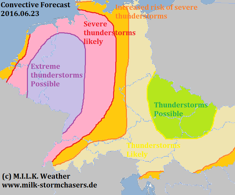
The weather setup with severe thunderstorms throughout central Europe is not over yet, and once more, very powerful thunderstorms may form over the course of the day, especially in the east of the forecast region. Main risks will be large amounts of rain (up to 80l/m² per hour), severe storm gusts exceeding 120km/h, hail up to >4cm in diameter, and an increased chance for a tornado event, especially in the evening hours.

2016.06.25

2016.06.24 – Convective Forecast

The very dangerous setup in central Europe will continue to produce thunderstorms today, many of which may become severe. Currently there are still some strong thunderstorms ongoing in western Germany.

The focus of thunderstorms in Germany will be in a diagonal line more to the center today, with the most severe thunderstorms expected to form in the northeast and the southwest. In Germany, large hail with a diameter of 5cm or even greater will be the main risk again, accompanied by storm gusts up to 100km/h and intense rain of over 40 l/m² in an hour or less. There is also an increased chance for tornadoes.

In the southeast of the forecast region, the main risk will be strong rain, but large hail may also be caused by the storms in that region.

2016.06.24

2016.06.23 – Convective Forecast

Because of the possibility of a very dangerous severe weather situation in central Europe today, M.I.L.K. decided to issue a convective forecast. The main risks in today’s thunderstorms are storm gusts, large hail and, to a lesser extent, tornadoes. Below is the M.I.L.K. Weather convective forecast.

2016.06.23