Updates.

Updates.


Updates.

Updates.

Updates.

Updates.

Updates.

Updates.
To find out what time in UTC it was when the posts were published, hover your mouse over the date next to the post.
Curently we see many scattered rain showers along a line from the N to the S, pretty much central in Germany. Most of the rain showers, and the strongest ones as well, are located in the SE. In N Austria there are showers as well and in Salzburg it is now currently raining. over poland there is a very big area of rain.
Hurricane Humberto is now longer a hurricane: Humberto has just been downgraded to a tropical storm. But this storm is expected to live for a long time still.

Updates.
40cm at -5°C:
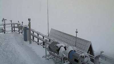
The highest mountain Germanys, that is located on the border between Germany and Austria, is already in deepest winter. In the past night there was strong snowfall there. This morning the snow on the mountain was already 40cm deep, the thermometer read -5°C. With those measurements the Winter came to the 2,962 m high mountain. Already yesterday the mountain was powdered white already, but with 5cm the snow layer was still relatively thin. Today it still snowed, so that the 50cm might be topped. The melting glacier on the Zugspitze is profiting from this sudden winter: the glaciers melting period is now most likely stopped for this year. It snowed today until 15:30 local time.

At the “forschungststation Schneefernhaus”, a second weather station on the mountain, you can see a small pathway for the Meteorologists on the observation plattform through the snow. Since this is not the weather station that is at the peek, in the morning it was a little warmer than -5°C.

Live image of the Schneefernhaus Webcam. Updates.
The first weather services and/or websites have now started giving out information and early-warnings about the storm that will strike especially northern Germany and also Great Britain at the beginning of next week. While M.I.L.K. was by far faster, now the well known website WetterOnline published the first warnings; even with a video. Usually videos are just used on WetterOnline if there is an special case. The link to the video you can find below.
http://www.wetteronline.de/wetter-videos?cat=29&day=13&month=09&sort=date&token=hs&year=2013
The tropical storm Gabrielle has now been downgraded surprisingly far to the north, off the E coast of the USA. The hurricane Humberto, though, still stayed a hurricane. The tropical depression TEN still stayed a tropical depression, although the TROPICAL STORM WARNING IS STILL IN AFFECT.
Humberto is expected to weaken very soon.

Updated satellite image and live location of storm systems

Updated warning of Mexico
This Waterspout formed along a front over the lake Michigan, lived several minutes, but did not cause any damage because it stayed over water.
Thunderstorm: Around Dresden thunderstorms are to be expected today.
Storm: Around München storm is to be expected today.
Storm and Snowfall: none