Two tropical systems are currently being watched by NOAA’s National Hurricane Center – one a hurricane in the eastern Pacific, one a tropical storm in the vicinity of the Bahamas. Here are the details
Tropical Storm Humberto
Central Pressure: 1000 hPa Maximum sustained winds: 93 km/h Gusts: 110 km/h
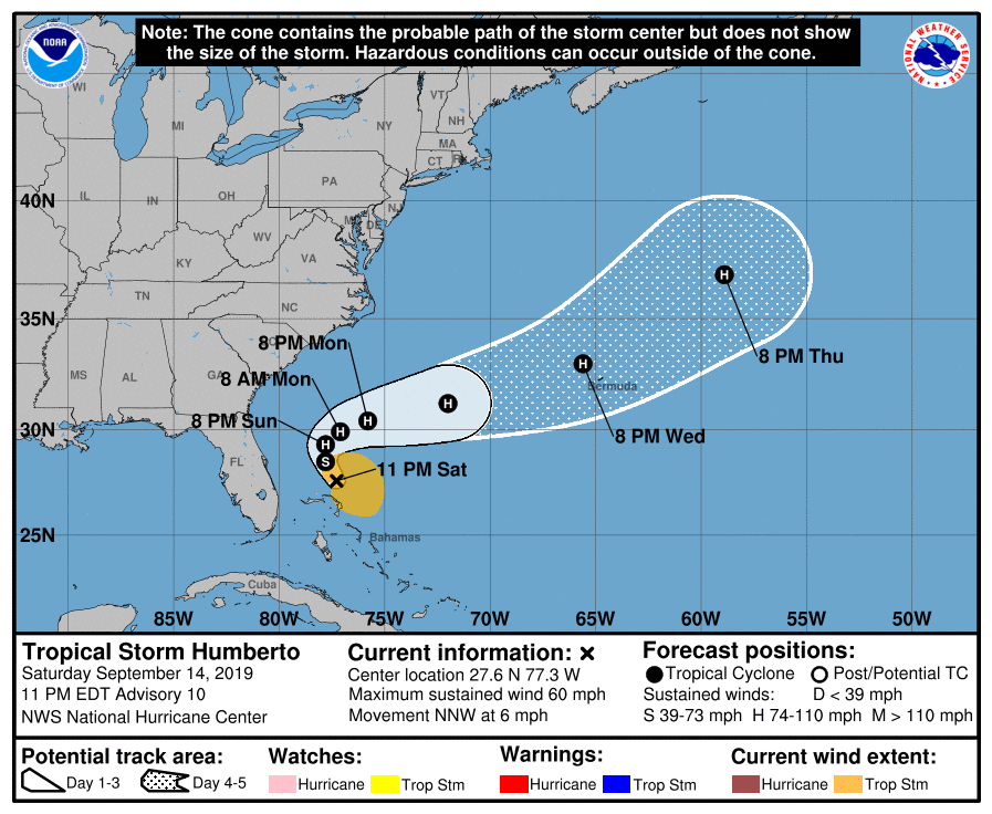
Tropical Storm Humberto is currently located just to the north of the Bahamas, its precipitation and even its storm field affecting some of the nation’s islands. It is currently not predicted to make landfall in the mainland US, instead turning back out to the Atlantic and then heading towards the Northeast. The storm is, however, still expected to strengthen and is predicted to be upgraded to a category 1 hurricane by 8pm on Monday (EDT), and a category 2 by 8pm on Tuesday (EDT). On Wednesday, the storm is expected to be positioned around Bermuda. Whether the British territory is going to be struck isn’t entirely certain yet, however, precautions should be taken.
The current storm field and predicted path of Tropical Storm Humberto. Note how part of the Bahamas is currently being impacted by the storm field. Source: NOAA / NHC
Hurricane Kiko
Central pressure: 966 hPa Maximum sustained winds: 184 km/h Gusts: 211 km/h Category: 3
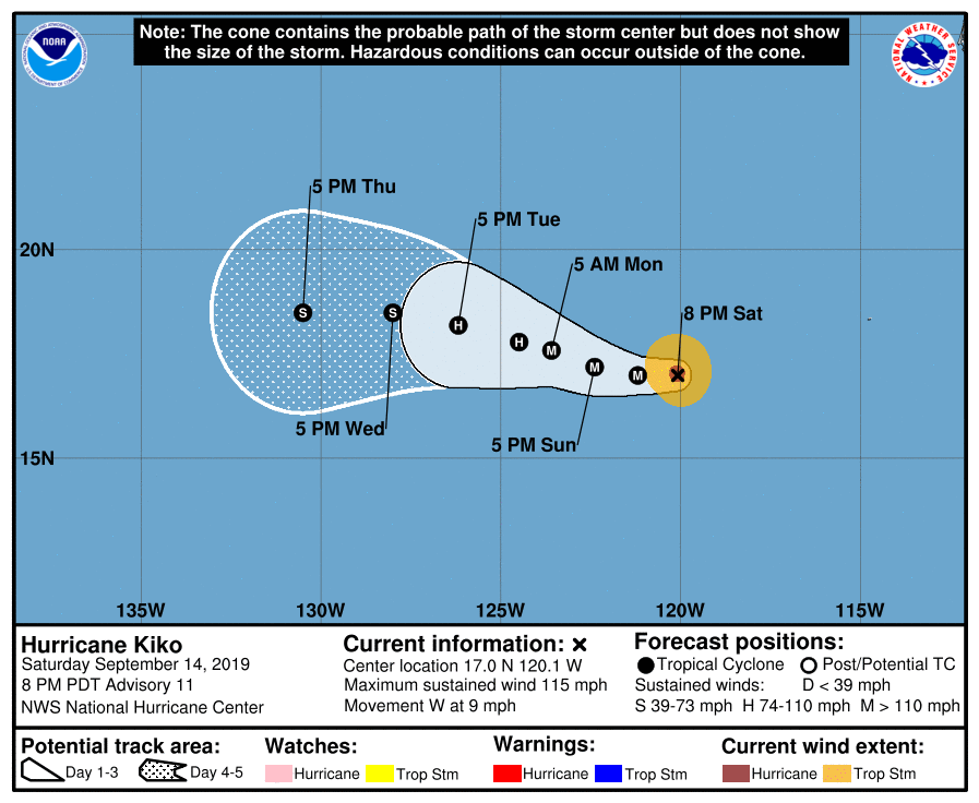
Hurricane Kiko, though a major storm, is located well out on the Pacific and is headed Westwards, away from land. It therefore poses no real risk to North America. The storm is expected to continue on this trajectory for the days to come, eventually weakening to a category 1 storm by the end of the 5-day forecast period.
Hurricane Kiko, though a major hurricane, does not pose any threat to mainland North America at this time. Source: NOAA / NHC.
Storms coming from the Atlantic, like this one, are the reason Europe receives so much rain. Image: NASA
There’s a reason the British came up with the phrase “raining cats and dogs”, and for why Germany appears to perpetually be in a bad mood. Western Europe receives a lot of rain. To be exact, London gets on average 630 liters per square meter (1 l/m² = 1 mm), Berlin 566 mm and Amsterdam tops both, at 810 liters annually. But why’s that?
Simply put, the reason it rains so much is because all of western Europe is close to the ocean – you are usually less than a thousand kilometers from the next coast, and on a global scale, that is almost no distance, nor is it for the humid air moving in from the Atlantic. This air eventually deposits most of its water in western Europe.
In more scientific terms, Western Europe is classified as having a “temperate climate”, meaning that there are four distinct seasons, with warm summers and cold winters, and that there is precipitation year-round. The British Isles, the BeNeLux, Germany, Denmark, the south of Sweden, south and west of Norway, all of Germany, Austria, Czechia, and much of Poland and the inland of the Balkans as well as the north of Spain fall under this classification, as do the western coasts of Iceland and the Baltic states. Further to the east, continental climate takes over, which is a lot drier than Western Europe’s rainy weather, and in the south, along the coasts of the Mediterranean, Mediterranean climate persists, with hot, dry summers and cooler, rainier winters.
Generally, the further east you go, the drier it gets, as the moisture-laden air from the Atlantic needs to cross larger areas of land, therefore typically losing its water on the way before continuing into areas such as Belarus and Russia.
Europe is surprisingly far north. At 52° North, the German capital, Berlin, is 9° further
A satellite image of the Sea Surface Temperatures of the Northern Atlantic clearly shows the warmer water being transported north by the Gulf Stream. Image: NASA
North than Toronto, and even 1° further north than Alaska’s southernmost city. Nevertheless, temperatures rarely drop far below -5°C in winter, and commonly exceed 25 and even 30°C in summer. A key contributing factor to the mild weather in Europe is the Gulf Stream – an ocean current that transports warm water from the Caribbean and the Gulf of Mexico all the way to the Northern Atlantic – both increasing Europe’s temperature, and providing the fuel for low pressure systems (bringing rain) and storms to form over the ocean, only to move eastwards and towards Europe.
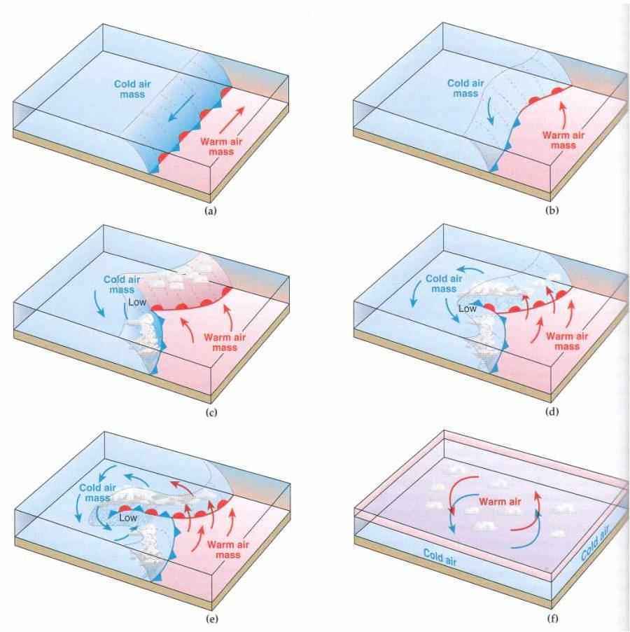
There is one final piece to unlocking the puzzle of why Europe is so wet, and that goes by the imposing name of “polar front”. In meteorology, a front is the place where two air masses (areas of air with different properties, usually temperature) meet. In the case of the polar front, warm, moist air from the south clashes with cold, moist air from the north. When air masses clash, they shove each other around and lead to the formation of weather patterns. In this case, low-pressure systems are formed (which has the fancy name of cyclogenesis). And low-pressure systems typically pack rain.
The formation of a low pressure system, a.k.a. a cyclone (not all cyclones are tropical storms!). In the case of the Atlantic, the line where the arctic and subtropical air meet is called the polar front. The entire process is called cyclogenesis. Image: classconnection.s3.amazonaws.com/814/flashcards/364814/jpg/formation_of_a_wave_cyclone1322859884968.jpg
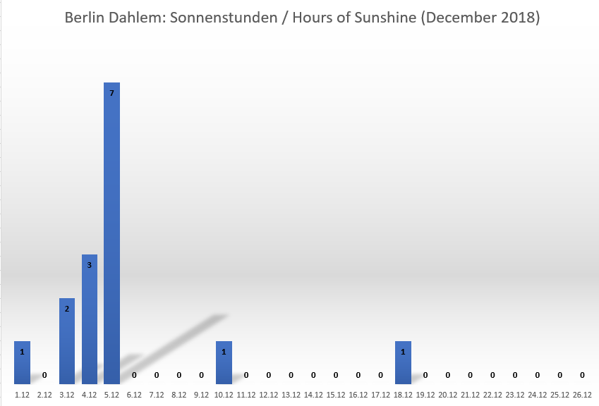
Fragt man Berliner, was sie am Winter am meisten stört, so ist es normalerweise nicht die Kälte. Mit Temperaturen die normalerweise in den einstelligen Plusgraden liegen ist häufig knapp zu warm für Schnee. Vielmehr stört die Berliner der bedeckte, oft tagelang konturenlose Himmel. Auch 2018 brachte wieder eine “Hochnebelsuppe” vom Feinsten – wie die Daten der Station Berlin Dahlem belegen. Seit über einer Woche gab es keinen einzigen Moment Sonnenschein; insgesamt gab es im Dezember bislang unter 15 Stunden mit uneingeschränktem Naturlicht.
If you ask residents of Berlin about what annoys them most about their city’s winter, it usually isn’t the cold. Temperatures usually reaching single-digit positive values, it typically is to warm for snow. Much rather, the reason for the Berliners frustration is the overcast sky, which often stays without any contours for days. 2018, too, brought one of these “grey soups” to Berlin – evidenced by the data collected at the meteorological observatory Berlin Dahlem. In the past week, there hasn’t been a single moment of sunshine; in total, December has brought less than 15 hours of unimpeded insolation so far this year.
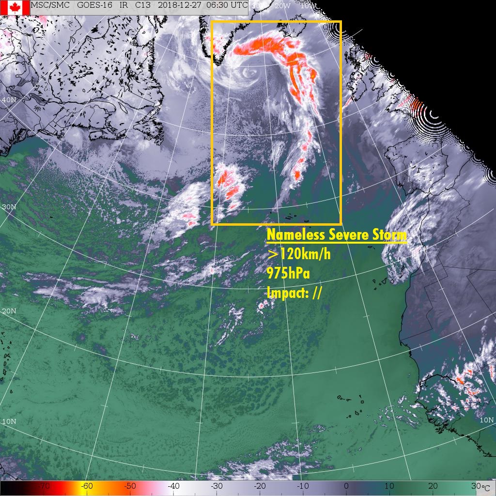
A severe storm packing wind speeds in excess of 120km/h is currently located over the northern Atlantic, roughly to the south of Greenland and southwest of Iceland. The storm, which had a central pressure of 975hPa in the last analysis, is not expected to make landfall in any European countries (Iceland included) before it dissipates, therefore posing minimal risk. No warnings or watches have been issued for it.
However, a new storm is expected to form over the Atlantic during the 48 hour forecast period. It may move towards the British Isles by the end of said forecast period, potentially hitting the northern coasts of Ireland with storm gusts and possibly even bringing some severe storm gusts in excess of 120km/h to Scotland. This would take place in the night from Friday to Saturday. As this is still a while away, changes in the forecast are possible. For now, a storm watch and severe storm watch have been issued for Ireland northern & northwestern coasts and for Scotland, respectively.
Below you will find the current storm warnings & storm watches, the satellite image of the storm and the overview of the currently active systems.
This forecast is solely for informative purposes and though is done to the best of the forecaster’s ability, no warranty is given for the accuracy of the information.
Storm PHILINE, currently located over Denmark, is expected to more or less dissipate within the next 24 hours, and is currently only bringing storm gusts to a fairly small area consisting of Denmark and the far north of Germany.
However, from the northern Atlantic, a new storm is approaching: severe storm QUINN, currently located to the northwest of Ireland, is packing gusts exceeding 120km/h and has a central pressure of 988hPa. It is expected to strike Ireland and, a few hours later, the UK in the coming night, bringing wide-spread storm gusts and some severe storm gusts, especially in exposed locations. The storm will move northeast or north-northeast, and will also bring severe storm gusts to parts of Iceland by tomorrow morning. The French coast may be impacted between tomorrow morning and the early afternoon, as well. Storm warnings and watches have been issued accordingly. See below.
Below: ESC European Windstorm Overview, Warnings and Watches.